Key Data
Chapter Trail Section
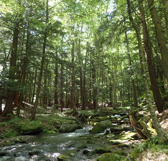
The Trail passes through approximately 97 miles of the ANF as it travels across the Allegheny Plateau. Its northern terminus is the PA/NY border and its southern terminus is the ANF border, 3 miles north of Route 66. This section has much to offer: Scenic views of the Allegheny reservoir, beautiful hemlock valleys, rock cities, fascinating evidence of past and present logging and oil industries, and many opportunities to view wildlife, including bear, deer, coyote, fishers, bobcats, songbirds, grouse and eagles. Varied habitats and terrain, along with frequent camping sites, make the NCNST through the ANF a great destination for a day hike or a backpacking trip.
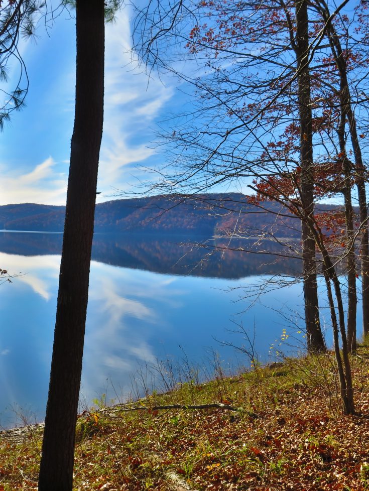
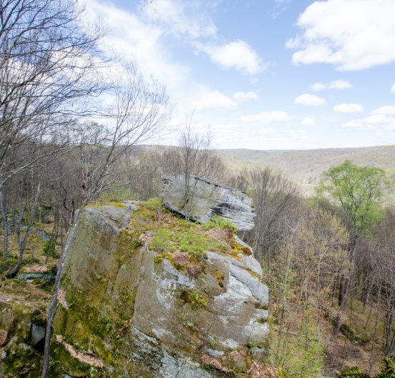
There are many special places along the ANF section. In Tracy Ridge, the Trail runs on the eastern side of the Allegheny Reservoir, allowing for many scenic views and much solitude. The Trail passes through the Tionesta Scenic Area where remnants can be found of an old growth forest that was mostly destroyed by a tornado in 1985. The Trail now highlights the rebirth of this forest. Rock cities dot the terrain on many of the ridgelines. The most scenic of these are found in the popular Minister Creek valley.
Filterable water is plentiful in the ANF. The only dry stretches are a few miles across some ridgelines. There are over 30 marked campsites along the Trail in this section. U.S. Forest Service campgrounds with services are also available nearby. Dispersed camping is legal throughout the ANF. Cell phone service is limited: Texting is often available but there are few places to make a call. There is very limited resupply along this entire route.
Connect and Get Involved
Join the Chapter
Chapter Meetup
Ways to Volunteer
anf@northcountrytrail.org
Facebook
Resources
Use the Report Trail Condition form to alert NCTA and the Chapter to poor trail conditions. Visit the Trail Alerts page while planning your adventure.
Suggested Hikes
See photos of all locations at the bottom of this page.
Solitude, 16.3 miles. Route 346 at Willow Bay (41.984452, -78.902351) to Route 59 (41.857424, -78.859646). This section follows the eastern side of the Allegheny Reservoir allowing for many scenic views and varied terrain. The hiker passes through rock cities and lovely hemlock lined creek valleys. The Tracy Ridge area is a large roadless tract allowing for solitude and tranquility. This area also offers the opportunity to hike a loop by connecting to the ANF Tracy Ridge Hiking Trail System. Great camping is found along the shore of the lake at Tracy Run, Johnnycake Run and Handsome Lake campground and in the Tracy Run Shelter. Beautiful camping spots and the Hammond Run Shelter are also located farther south along Sugar Run and Hammond Run.
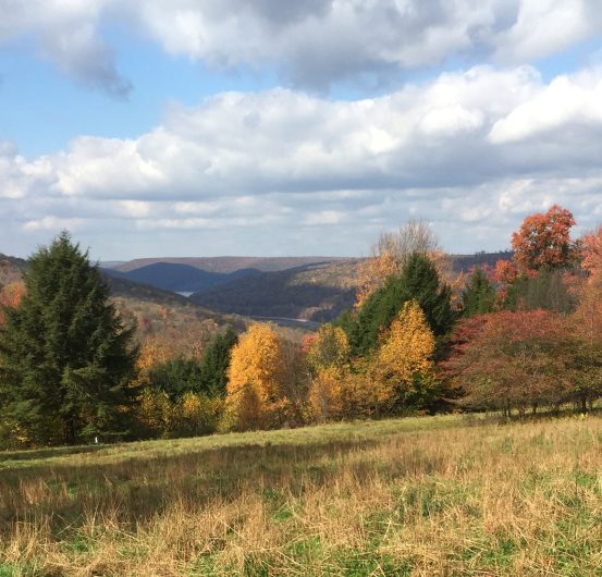
Hills, 19.5 miles. Route 59 (41.857424, -78.859646) to Route 6 (41.710829, -78.909101). This section starts by crossing a ridgeline that is the source of Hemlock Run. The Trail follows the beautiful Hemlock Run, Chappel Run and Chapel Fork to the top of the next hill where growth from recent logging activity is evident. The Root Run valley that follows, brings the Trail back to reservoir level and allows the opportunity of encountering osprey on their nest. Next is a climb to a meadow at the top of Bliss Hill with a sweeping view of the Kinzua Arm of Allegheny reservoir. The Trail passes through peaceful pine forests on Gibbs Hill before reaching Route 6. There’s lots of opportunity for camping as the Trail passes Chapel Fork shelter, Gibbs Spring shelter and several campsites.
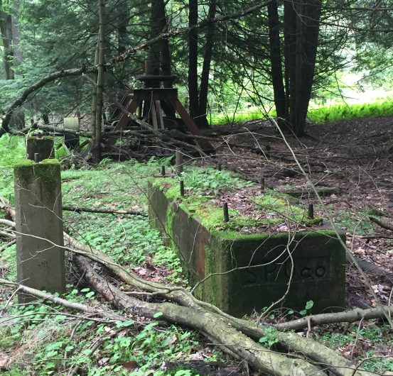
Rebirth, 14.7 miles. Route 6 (41.710829, -78.909101) to Route 666 at Henrys Mills (41.635999, -79.04286). After crossing Route 6, the Trail passes through beautiful forest and interesting rock formations to the Tionesta Scenic Area. The remnants of this old growth forest were mostly destroyed by a tornado in 1985 and the Trail highlights the rebirth of the forest. The Trail continues through Cherry Run with a large rock city near its headwaters and great camping at the rock city, at the Cherry Run Shelter and at its junction with the East Branch of the Tionesta Creek. The last segment of trail shows fascinating evidence of past and present oil and gas industries, including the foundation of a rod house just before the stunning switchback leading down into Henrys Mills.
Rock Cities, 15.8 miles. Route 666 at Henrys Mills (41.635999, -79.04286) to Forest Road 116 (41.671899, -79.226598). The Trail switchbacks up to an old rail road grade that was used in the early 1900s to transport timber to sawmills. An old rail car can be seen abandoned alongside the trail. Evidence of early equipment used for oil pumping is also visible here. Rolling hills take you through the scenic Upper Sheriff, Lower Sheriff, Fool’s Creek and Minister Creek valleys. A shelter is located on the Upper Sheriff and great camping is also found at the Pell Run, Lower Sheriff and Minister Creek valleys. Minister Creek valley, a wilderness study area, is a popular hiking destination with many beautiful rock cities.
Creeks, 13 miles. Forest Road 116 (41.671899, -79.226598) to Route 666 Tionesta Bridge (41.544966, -79.255265). This section contains the least elevation change along the NCNST in the ANF, but is among the most beautiful. It follows scenic hemlock lined creek valleys, passes over beautiful Beaver Run and has a gushing spring, located on a 0.1-mile connector trail. The Queen Creek shelter is located 1.5 miles south of Forest Road 116. Other camping is located along Coalbed Run, Beaver Run and East Fork. There is an Army Corps of Engineers Campground at the Tionesta Creek Bridge.
Beaver, 18.2 miles. Route 666 Tionesta Bridge (41.544966, -79.255265) to Route 66 (41.419296, -79.210856). The Trail passes through the Kellettville campground to get to the Branch Creek. Free backpacking sites are available there. After crossing Branch Rd, campsites can be found along the Branch Creek or farther along at the Branch Shelter. It then goes through a young forest regrowing since the 1985 tornado. Here it passes through a beautiful rock city. Next the trail parallels Four Mile Run before climbing over the ridge into Guiton Run. Several spots offer views of Salmon Creek valley. The picturesque Little Salmon Creek valley shows evidence of past beaver activity and nice camping by the bridge. Other camping is located in the Four Mile valley and at the Amsler Spring shelter. After the shelter, the trail crosses up and into the scenic Coon Creek valley and its beaver dams. Finally, the Trail passes through State Game Lands #24 before arriving at the Route 66 trailhead.
Chapter Maps and Guidance
View our section of the Trail on the interactive online map
Campsites in the Chapter’s section
Geocaching guide
Geocaching codewords sheet
Additional Local Resources
Shuttle services, Allegheny Outfitters Outdoor Store (They request a two-week notice.)
U.S. Forest Service, Allegheny National Forest (Offices in Warren, Bradford, and Marienville)
Chapman’s Dam State Park
Geocaching
Warren County Visitors Bureau
Warren County Chamber of Business and Industry
Allegheny National Forest Visitors Bureau
Kane Area Development Center
Tionesta
Marienville
Cougar Bob’s Kellettville Tavern (and restaurant), Tionesta
Paul's Trading Post, Kane