What to expect
The trail is nearly 5,000 miles long and crosses a variety of public and private lands. Rules and regulations vary from state to state and sometimes mile to mile. The trail is primarily a footpath, but some segments allow horses or bikes, and some segments are along roads – though we’re working hard to change that.
Camping options and rules, such as leash laws, vary across the trail, too. Please reference our maps to learn who manages the lands where you plan to hike, and follow their guidance. Our maps also include water sources, though some may only be available seasonally.
For questions about trail conditions in specific segments, as well as local rules and regulations and shuttle inquiries, please reference our Trail Alerts page, or contact the NCTA Chapter or Affiliate organization responsible for the segment you’re interested in. You can see this information when selecting a segment of the trail on our online map. A list of Chapter and Affiliate acronyms can be found on the Contact page.
Navigation
An online map, downloadable and printable PDF maps, and GIS data are available for free at northcountrytrail.org/trail-maps. All data is maintained by NCTA staff. It is ground-truthed by staff, volunteers, and partners. Updates are published twice each year. The NCTA also supplies its GIS data to FarOut Guides, which users can access through the FarOut app for a fee.
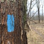
The North Country Trail is traditionally marked with bright blue blazes – vertical rectangles – painted on trees or posts, as well as the iconic National Scenic Trail rounded triangle signs that feature the North Star. Many segments of the trail share their corridor with other trails, so signage will vary. For example, on the shared North Country / Finger Lakes Trail in New York, the blazes are white. And in federal Wilderness areas, blazes are not allowed. Ultimately, on-trail signage cannot be solely relied upon for navigation across the entire trail. We strongly recommend planning ahead and hiking with a map.
Hike 100 Challenge
The North Country Trail Association offers a free hiking challenge each year. Spend 100 miles on the North Country Trail in the calendar year to earn a collectable patch. Learn more, sign up, and submit your completion form at
northcountrytrail.org/hike-100-challenge.
National Park Service information