Any current North Country Trail closures or reroutes will be posted here as staff are made aware.
Check this page before each hike, or contact the Chapter or Affiliate who maintains the trail in the area you plan to hike. If you encounter an issue on the trail, please report it using this form.
- Dead Colt Creek Recreation Area. The Colton’s Crossing Bridge is closed – even for pedestrian use.
- McClusky Canal – Lonetree Wildlife Management Area. Rough road – not mowed. Use caution while hiking.
- Lonetree Wildlife Management Area. ND Game & Fish is doing a prairie restoration that should be complete in 2029 – now it’s planted to row crops. Hikers should follow the mowed detour south of the field and then along its eastern edge
- Lonetree Wildlife Management Area. The ND Game & Fish is using active cattle grazing along the NCNST as a land management tool and the rancher is employing electric fences. Some of these electric fences cross the NCNST and most have stretch clip gates. To pass through, simply unhook the clips from the fence post and walk them away from the post (you won’t get shocked), walk through, and then re-attach the posts. The Parking area on 19th St. NE has a fence across the entrance but NCNST parking is allowed.
- Sheyenne National Grassland. NCNST users should expect to encounter grazing sheep and their guard dogs in between May 1 and October 1. The sheep rotate throughout different pastures along the NCNST in between mile posts 10-31 (covered on maps ND-071 through ND-075). The sheep herders are instructed to keep the sheep away from the Trail as much as possible but it’s not always the case. Read the “Do’s and Don’ts” on the U.S. Forest Service sign (posted along the NCNST) about how to safely interact with the guard dogs. If folks are planning a hike on the NCNST and are concerned about specific areas, they can call the Sheyenne National Grassland office at (701) 683-4342 and ask what area the sheep are in at that specific time.
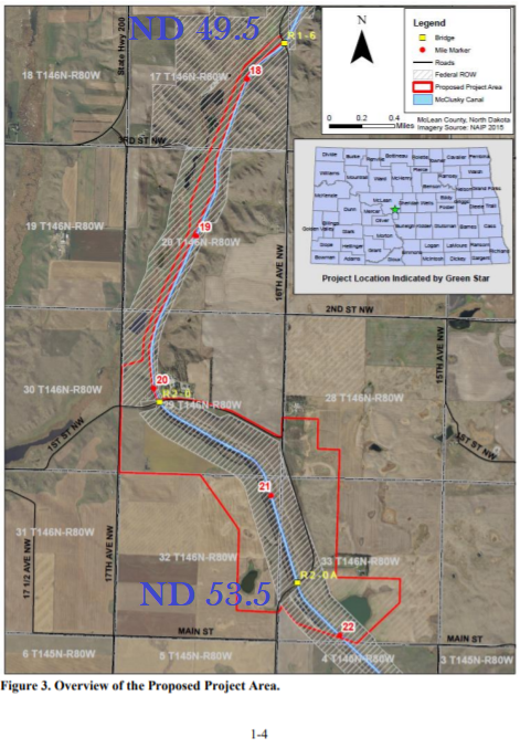
- McClusky Canal. There is a major trail detour in central North Dakota because of a slide repair project on the McClusky Canal on the McClusky Canal that will be going on for the next 3+ years. The NCNST section to be bypassed is covered on maps ND-009 and ND-010. https://arcg.is/nPr9H0
-
Tamarac National Wildlife Refuge. The 400th Ave. / Rogstad Campsite is CLOSED as the property is now owned by the U.S. Fish & Wildlife Service, which does not allow overnight use. A new campsite location will be built this spring just a little further east off of W. Island Lake Dr.
- Grand Rapids. There is a construction project that has temporarily closed a section of the paved multi-use trail between the Forest History Center and the Grand Itasca hospital. Hikers should walk CR-76 and SW 8th Street around it until completed.
- Cass/Itasca County border. The NCT is cleared and blazed east of Hwy 6 and the tread is constructed to the new campsite just east of the little pond.
- Calumet. Hill Annex Mine State Park is permanently closed due to iron ore mining operations.
- Mesabi Trail. The Mesabi Trail between Embarrass and Tower will be completed in late summer 2026. For more details, visit https://mesabitrail.com/plan-
your-trip/trail-updates-and- conditions/ - Clearwater County Forest. Salvage logging to occur west of CR-39 this fall – closing the NCT between Mackenzie Forest Rd and CR-39.
- Tamarac NWR-Itasca-Lake George-Bemidji. Hikers should expect some remaining downed trees on the trail throughout this area as a result of the June windstorm. The LLC Chapter has cleared as far east as the CR-39 trailhead west of Itasca State Park.
- Superior Hiking Trail. Popular segments of the Superior Hiking Trail / NCT are currently closed for rehab or bridge work. Find more https://superiorhiking.org/
trail-conditions/ - Rochert. The NCT is currently flooded south of the Otter Tail River ford where it goes around a private land cornerpost. The water may be up to 12″ deep. Note: this flooded spot is between the white- blazed ford bypass trail and the river ford.
- CR-17. The NCT is now complete from CR-17 west to Loons Call Rd but this is currently a dead-end segment. Hikers’ vehicles are not allowed on Northwoods Trail (a private road) or Loons Call Rd but a new parking area is available here.
- Lake Vermilion State Park. From MM412 in Lake Vermilion State Park, there are backcountry campsites (fee required) just off the NCT’s route on the Mesabi Trail. See https://files.dnr.state.mn.us/maps/state_parks/spk00285.pdf.
- Heart of the Lakes Trail. From MM72.5 to MM80.75, the NCT now follows the Heart of the Lakes paved multi-use trail which lies adjacent to the roads. This NCT segment is not yet signed.
For trail alerts along the Superior Hiking Trail, visit the Superior Hiking Trail Association’s Trail Conditions web page. For Trail alerts along the Border Route Trail, visit the Border Route Trail Association’s Trail Conditions web page.
- Casey Sag Road. A new trailhead parking area is available off of Casey Sag Rd. with a short spur trail to the NCT.
- Highway 169. The road paralleling the NCT just south of the middle crossing of Hwy 169 is a gated private road – no public access is available to the NCT.
- Copper Falls State Park. Dogs are not allowed on the Doughboys Nature Trail portion of the NCNST within Copper Falls State Park. NCNST hikers with a dog should plan to take an alternative route. The park can be reached at (715) 274-5123.
- Enbridge has begun their Line 5 Segment Relocation project that intersects the NCT in the Mellen to Gurney area. Trees are cleared on the pipeline corridor and heavy construction starts in May 2026. Expect heavy construction traffic on Vogues Road and Box Spring Road (Wisconsin miles 204.25 to 202.5). Temporary NCT detours / closures may be possible from 185.75 to 187. The NCT at Wren Falls is best accessed via Casey Sag Road (off of Highway 77) to Sullivan Forest Road to Wren Falls Road.
- Pictured Rocks. A prescribed burn in the Miners Beach area is planned to take place no later than June 30. Weather conditions will determine the specific time but is expected to last 1-2 days. NCT hikers will have the opportunity to be safely escorted around the closer.
- Brevort Dam Rd. Parking at the end of Brevort Dam Rd will not be accessible as the road bridge over Brevort River will be replaced. Construction is planned between June 15- August 31.
- Eastern Ottawa National Forest. During spring runoff it is best to use the high water bypass to avoid Boulder Creek and Silver River.
- 12 & 15 Roads and trail NE of Mesick. 12 Rd is closed due to a sinkhole. 15 Rd is passable but all/4 wheel drive is strongly advised due to multiple swales. East of the parking area the NCT is flooded with multiple structures still under water. Avoid this section if possible.
- N. Branch Boardman River – Between 605 and Broomhead Rd. Due to flooding and erosion follow the flagged reroute for approx. 0.3 miles
- High Bridge Rd – Manistee River. The section of trail that is adjacent to High Bridge Rd has been deemed closed due to erosion from flooding events. The road itself is also closed between River Rd and Chicago Ave. Please avoid this area. For long distance hikers follow the road walk from M-55 to Coates Hwy as shown on our online map.
- Kalamazoo County – north of M-89. Due to logging, there is a blazed temporary reroute following other existing trails.
- Battle Creek Linear Pathway. The M-89/Washington Ave road bridge is being replaced. The roads leading to the bridge are barricaded so trail users will have to make a slight reroute around them. Follow the signage on the ground. Construction is expected to last until October 9th.
- Tahquamenon Falls State Park – River Trail Between the Falls. From the Michigan DNR: For the safety of visitors, the 4-mile River Trail connecting the Upper and Lower Tahquamenon Falls is closed for the winter due to unsafe conditions. Already this winter, downed trees, flooded portions of trail, deep snow and extremely slippery footing, especially on staircases and sloped areas, has been observed. When injuries occur, it’s very difficult for park staff to reach these locations to provide medical assistance. The trail will reopen when conditions allow, which is anticipated in mid-May 2026.
- Yankee Springs – Hall Lake. This parking area is closed while the lake is being drawn down for work on the dam.
-
Northern Lower – Harbor Springs. Due to the spring 2025 ice storm and logging operations planned throughout winter please follow the signed reroute following N Conway Rd and Valley Rd until scouting can commence in spring of 2026.
- Ontonagon County- Downstream from the Victoria Dam. The river crossing can become impassable at times due to water released from the Victoria Dam reservoir. The dam releases water until mid-June or later for fish migration. Dam also releases water when there has been significant rain in the day(s) before. You can try to call the dam operators office (906-886-2637) and leave a message for a return call asking if water is being released from the dam. Their answer is rain dependent, so they will not know many days ahead of time. Or visit uppco.com/hydro-water-levels and scroll down to Ontonagon River > Victoria > Total Flow. If the Total Flow is greater than 650cfs they will be releasing water from the dam. The highwater bypass follows Victoria Dam Road and US-45 on this route. The route is only three miles longer than staying on the Trail and takes you into Rockland where there is dining, supplies, a post office (limited hours), and lodging.
- Copper Peak Rd, Gogebic County. Copper Peak Rd, between Black River Rd, is closed due to the construction of the Copper Peak Phase 1 Project. Follow Black River Rd during this time.
-
Little Miami State Park. ODNR is repairing segments of the Little Miami Scenic Trail with heavy machinery at the intersection of OH 350 north to Wilmington Road. Recreational use is unsafe and ill advised. Please plan alternate routes to avoid this segment. Road walk alternatives in the area are extremely busy with blind, steep curves. Avoidance of OH 350 is encouraged.
- South Lebanon. Due to infrastructure improvements, a section of the NCT/Little Miami Scenic Trail near South Lebanon will be temporarily closed. A north and south detour will be signed on the ground.
- Roundbottom Road. Please exercise caution and remain alert while hiking through this area. The Trail is routed along a busy roadway between Perintown and South Milford.
- Malvern to Waynesburg. Please exercise caution on this stretch of Citrus Road road due to ongoing construction from utility improvements.
- Magnolia. The one mile segment of off-road NCT between OH E 8.7 to OH E 9.7 west of Magnolia, OH has been closed by the landowner. Hikers should follow the road walk blazes on Imperial Rd. NW and Magnolia Rd. NW to bypass this section until the issue has been resolved.
For other trail alerts along the Buckeye Trail, visit the Buckeye Trail Association’s Trail Alerts web page.
- Clarion. A segment of NCT has been closed by a landowner at Highland Drive and Miola Road. Heading westbound hikers should turn left on Miola Rd and follow for 0.5 miles until Sawmill Rd. Turn right and continue until you intersect with NCT. This closure is signed on the ground.
- Allegheny National Forest, Tracy Ridge. The NCT traverses both Johnnycake and Tracy Run. Currently there are no structures in place at these crossings. Crossing may be dangerous due to changing water levels, especially during winter temperatures, spring runoff or after a significant storm event. All users should exercise caution in this area and be aware of current water levels. Approaching Tracy Run from the north, the only detour is to doubleback on the NCT and exit the system. From the south, hikers can doubleback to the Tracy Ridge trail connector and exit the system or return on the NCT. Due to the remoteness of this area, checking maps ahead of time for route planning is advised.
- Shippenville. The NCT goes through PA SGL 63 where it traverses Deer Creek and there are no structures for passage. This crossing may be dangerous due to the changing water levels, especially during spring runoff or after significant storm events. All users should exercise extreme caution in this area. Detour as follows: From West – Take Bryners Mill Road North to Rt. 322 to Rt. 66 South back to the NCT. From East – Take Rt. 66 North to Rt. 322 East to traffic light in Shippenville. School St. turns into Bryners Mill Rd, take south to NCT.
- Watkins Glen State Park. The park is replacing the Sentry Bridge. Starting in January 2025, the NCT/FLT will be detoured for the duration of the project (estimated completion July 2026). The temporary route north crosses the gorge at the suspension bridge, follows the North Rim trail between that location and the entrance to the park where it will re-connect with the existing trail. Detour will be marked in the field and can be viewed on this map.
- Stone Dam Trail. Due to the bridge being out over Little Woodhull Creek on the Stone Dam Trail, the NCNST has been rerouted from Stone Dam Trail. Now continue to follow North Lake Rd to Little Woodhull Trail to Sand Lake Trail to Bear Lake Trail.
- Adirondack Park, North Branch Trout Brook. Challenging ford over Trout Brook. Choose footing carefully and plan for a wet crossing.
- Adirondack Park, Crane Pond Trail. The trail is flooded in this area. An alternative route is available to the north.
- Durhamville. The Oneida Creek bridge on State Route 46 has been completely removed. A 5+ mile detour is marked at ST 31 and ST 46 on the north end as well as at Canal St. and ST 316 at the south end.
- Crown Point. The Crown Point State Historic Site is currently undergoing a Unit Management Plan update. The proposed NCNST route which traverses the old fort ramparts has been submitted for approval in this process. Until then, use Grandview Drive as the NCNST route.
- Adirondack Park. Navigating the mostly undeveloped route of the NCNST in the Adirondack Park will require special planning preparations. You can find more information on our Adirondack page.
For trail alerts along the Finger Lakes Trail, visit the Finger Lakes Trail Conference’s Trail Conditions web page.
-
- Green Mountain National Forest, Oak Ridge Trail. The Oak Ridge Trail from the Route 125 side has a significant culvert washout about ½ mile from the parking lot. More information can be found on the Green Mountain National Forest website.
- Green Mountain National Forest, Oak Ridge Trail. The Oak Ridge Trail from the Route 125 side has a significant culvert washout about ½ mile from the parking lot. More information can be found on the Green Mountain National Forest website.
For trail alerts along the Trail Around Middlebury (TAM), visit the Middlebury Area Land Trust’s “Trails” web page.
For trail alerts within the Green Mountain National Forest, visit the Green Mountain Club’s Trail Updates web page.