Events
Hike Two: Wren Falls and Historic Gold Mine Hike
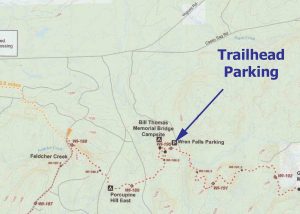
This 6.2-mile out-and-back hike with the Chequamegon Chapter features Wren Falls, the Bill Thomas Memorial Bridge, a scenic overlook, the site of an abandoned mine, and a couple of backpacker campsites.
We will leave a car at the Casey Sag Road trailhead so those who want a shorter hike, about 3.2 miles, have a way back to Wren Falls.
We will meet at the parking area for Wren Falls. The parking area is at the end of a 1.4-mile gravel road accessible from Vogues Road off State Highway 169 or Casey Sag Road off State Highway 77. The intersection of Vogues Road and Casey Sag Road is the start of the 1.4 miles road to Wren Falls (46.4134541, -90.5107097), and there should be a sign for the falls.
We suggest that you dress for the weather and bugs, wear a hat, bring bug repellant (perhaps a bug head net), water, lunch, and a snack.
The alternate date is July 25th. Please check the NCTA in Wisconsin Facebook Page for information about cancellations / postponements. This information will be posted after 6:00 PM the day before the hike.
![]()