Events
Petoskey, MI., Johnson Rd. to Brubaker Rd.
Just south of Petoskey, the Skyline Natural Area is one of the most scenic in the Jordan Valley 45° Chapter. This hike will be about 4.5 miles, plus maybe mile or so, to check out the Skyline Shelter and a viewing platform. It’s a 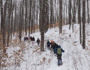 beautiful-but-hilly hike, and marks the watershed boundary between Lake Michigan and Lake Huron.
If the weather permits (low wind), we may have a campfire along with a picnic at the Skyline Shelter, which is about half mile from the Krause Rd. parking lot.
We will meet at the hike’s-end on Brubaker Rd. (624.75) [ Location: 45.341201, -84.890346] at 9:30 and by 10.00 drive hikers to the start at the Johnson Rd. (628.5) trail crossing. After the hike we will ferry drivers back to Johnson Rd. See mile markers here.
Hike Options:
Longer Hike:
• Johnson Rd. (628.5) to Brubaker Rd. (623.75) ~ 5.5 miles with spur trips to Skyline Shelter and the viewing platform.
Shorter Hikes:
• Starting at King Rd. (627.25) reduces the hike to ~ 4.25 miles.
• Starting at Krause Rd. parking lot (625.9) reduces the hike to ~ 3.0 miles.
Come prepared for the weather as snowshoes or ice cleats may be necessary. Don’t forget plenty of water and snacks. If there is interest, we will shoot into Petoskey afterwards for pops and sandwiches.
This fantastic section of trail is the north end of the hilly ridge that runs north/south between I75 and 131, from south of Petoskey to Thumb Lake. Most of the trail is high and dry and includes old growth forest.
The Jordan Valley 45 Chapter trail runs from Starvation Lake Rd. to Kipp Rd. in Harbor Springs, about 79 miles of awesome valleys, hills and wooded trail. Monthly hikes are usually on the 3rd Saturday of the month.
Questions? Call or text Bob Courtois at 248 212-6699.
Our next hike will be on April 19th, from Springvale Rd. to Harmon Rd. Details to be posted by April 1st.
![]()