Let’s hike the North Country Trail to, through, and from the NCTA Trail Town of Battle Creek, Michigan.
We’ll start at the southeast corner, at Historic Bridge Park, where the focus is on historic truss bridges that have been moved and restored, this is the first park of its kind in the U.S.
From there we hike through a wooded trail at Kimball Pines Park to the Ott Biological Preserve, a 300-acre nature preserve. Within its boundaries you will find two spring fed lakes, large wetlands and ridged uplands.
We then enter more of the residential city, at the intersection of Raymond Road and Emmett Street, where you will find a gas station supermarket and nice pub and grill. You then cross Veteran’s Bridge to the 26-mile-long Battle Creek Linear Park (BCLP), a paved hiking/biking trail. The NCNST follows a good portion of this “city park” through town.
 We follow the BCLP along the Battle Creek River to downtown Battle Creek, passing the Underground Railroad Sculpture, the largest in the U.S. dedicated to the Underground Railroad. Continuing along the river we pass by the old Michigan Central Railroad Depot, built in 1888 and currently housing Clara’s on the River, a very popular restaurant. This is about a block north of downtown Battle Creek where you can find a variety of eateries and two breweries, New Holland and Handmap.

You probably recognize Battle Creek as “Cereal City,” the birthplace of both Kellogg’s and Post Cereals. If cereal is being made, and the wind is blowing in the right direction you will likely find yourself thinking about your favorite breakfast cereal. At one time it is said that there were more than 100 companies trying to break into the booming cereal industry! Lots of money was made (and lost) back in the early 1900s.
We now follow the BCLP along the Kalamazoo River, coming to the intersection of Jackson Street and South Bedford Road. Just a block or two north is the Urbandale area with some restaurants, fast food, drug stores, gas stations, and hardware stores.
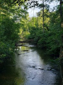
 Crossing the river and still on the BCLP, you hike through a nice wooded stretch and come out to Dickman Road (M-96), walking on sidewalk through a surprisingly quiet industrial park. You are approaching the end of Calhoun County and Battle Creek as you turn north on Armstrong Road, past the VA Hospital before entering Kalamazoo County and a very nice 3-mile stretch of Trail through the Fort Custer National Cemetery property. This trail offers some beautiful mature pine forests, low marshy areas with nice boardwalk, and a nice stream to provide some quiet reflection time. While you won’t see the actual cemetery, you will often hear the gun salute as military honors are given to deceased military personnel.
As you leave the Fort Custer area, you will be minutes from hiking through Augusta with several nice restaurants providing refreshments to weary hikers! We trust you will enjoy your time in Battle Creek, Michigan: the Cereal City!
The Chief Noonday Chapter is responsible for the North Country Trail section through Battle Creek.
Additional Resources
- McDonald’s: 1160 E Michigan Ave. (Mile 1089.3)
- McGonigle’s Pub & Grill (Mile 1086.3)
- Clara’s On The River (Mile 1083.3)
- Griffin Pub (Mile 1083)
- New Holland Brewery (Mile 1083)
- Handmap Brewing (Mile 1083)
- Barista Blues Café (Mile 1083)
- BIGGBY® COFFEE: 0 Hill Brady Rd. (Fort Custer Industrial Park) (Mile 1077.5)
Photos by Annie J. Kelley and J.P. Pitale
